
Millions of travelers faced significant disruptions across the northern United States as an intense arctic blast swept through the region following Thanksgiving. The severe weather system unleashed snow, frost, and dangerously cold winds, creating hazardous travel conditions and prompting winter weather alerts for approximately 9 million people nationwide.
The confluence of a southward-moving arctic air mass and the relatively warmer waters of the Great Lakes triggered intense lake effect snow, particularly impacting areas downwind of the lakes. Regions in New York state, Pennsylvania, and Ohio bore the brunt of this phenomenon, with nearly 3 million individuals under lake effect snow warnings. These warnings highlighted the likelihood of heavy snow showers capable of rapidly reducing visibility and making roads treacherous.
Winter storm warnings and winter weather advisories were in effect for over 2.3 million people across parts of New York, Michigan, Minnesota, and West Virginia. These alerts cautioned of heavy snow, ice, and blizzard conditions being highly probable, with advisories indicating the potential for rapidly accumulating snow, freezing rain, and blowing snow. Travel became “very difficult to impossible” in many areas, coinciding with one of the busiest travel periods of the year as people returned home after Thanksgiving gatherings.
Lake effect snow bands intensified on Sunday, renewing travel challenges in northeast Ohio, northwest Pennsylvania, western New York, and parts of northwest New York. These bands dumped fresh snowfall, adding to already significant accumulations. Jefferson County, New York, along the Black River, recorded an astonishing 46 inches of accumulated snow. Silver Creek in Chautauqua County reported 32 inches, while Calcium, a community east of Lake Ontario, received nearly a foot of new snow on Sunday alone, according to the National Weather Service.
 A couple makes their way through snow on a sidewalk
New York Governor Kathy Hochul declared a state of emergency in several counties on Friday, including Erie, Oswego, and Allegany, as the arctic blast intensified. Lake effect snow was forecast to persist in western and northern New York through Monday, with snowfall rates potentially reaching 1 to 4 inches per hour, according to the Governor’s office. Governor Hochul urged residents to avoid non-essential travel, and over 100 National Guard troops were deployed to western New York to assist local communities. Interstate 90 in western New York, which had been closed on Friday, was reopened to passenger vehicles on Saturday afternoon, offering some relief to stranded travelers. While a lake effect snow warning remained in effect for the region until Tuesday evening, Governor Hochul announced on Sunday night that the ban on buses, commercial trucks, and tractor-trailers would be lifted at 2 a.m. ET.
The highest snow accumulations were anticipated east of Lake Ontario, where isolated areas near Watertown, New York, could see up to 60 inches of lake effect snow by early in the week, according to the NWS. The Tug Hill Plateau was expected to be particularly hard-hit, with an additional 1 to 3 feet of snow forecast through Tuesday morning. In the Buffalo–Niagara Falls metropolitan area, Orchard Park could receive 8 to 20 inches of snow before Tuesday morning. The weather service office in Cheektowaga, New York, serving Buffalo, warned of “extremely hazardous travel” conditions overnight in the Southtowns of Buffalo due to active lake effect snow bands and the potential for up to 2 feet of additional snowfall.
Despite the challenging weather, the Buffalo Bills hosted the San Francisco 49ers for Sunday Night Football on NBC, winning 35-10 as snow fell at Highmark Stadium in Orchard Park, New York. Dedicated fans famously shoveled approximately 2 feet of snow from seats and aisles before the game. Following the victory, Bills quarterback Josh Allen and coach Sean McDermott celebrated the win by making snow angels on the field. Lake effect snow was also expected to spread to central New York and parts of the Mohawk Valley area from Sunday into Monday, with central New York potentially seeing up to 10 inches of snow and the Mohawk Valley region up to 5 inches.
Erie, Pennsylvania, had recorded 30 inches of snow, the highest amount so far, with federal forecasters predicting up to 6 feet of snow accumulation in northern Erie County by Tuesday. An additional 10 to 20 inches of snow was expected in the city itself. Brenton Davis, executive for Erie County, Pennsylvania, announced at a news conference on Sunday that private contractors had been hired to assist with snow removal across the region. He also recommended that schools in the county remain closed on Monday and Tuesday. National Guard troops were mobilized to transport residents needing assistance to warming centers in the county. Pennsylvania Secretary of Transportation Michael Carroll urged people in the region to avoid driving, stating, “Give us today and tomorrow to restore order to the transportation network.”
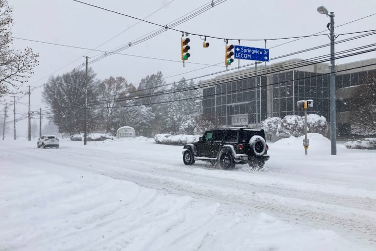 A jeep on a snowy road
The weather service office in Cleveland indicated that up to 18 inches of lake effect snow was possible from Cleveland to the Pennsylvania-New York state border on Sunday, potentially disrupting travel throughout the snowbelt region southeast of Lake Erie. Additional snowfall of 2 to 10 inches was expected through Monday in cities like Traverse City, Marquette, and Ironwood in Michigan, and Milwaukee in Wisconsin. Parts of eastern Kentucky and West Virginia remained under winter alerts on Sunday morning due to lingering scattered snow showers, with Charleston and Jackson, Kentucky, included in these alerts through the afternoon.
While the arctic blast primarily impacted the northern states, its reach extended south, bringing freeze warnings, watches, and frost advisories to over 4 million people in southern Georgia and northern Florida. Overnight lows in Lake City and Gainesville, Florida, were forecast to dip into the upper 20s and low 30s, threatening vegetation. The arctic blast also caused temperatures to plummet across the northern Plains, Midwest, and East Coast, dropping roughly 10 degrees below average, not accounting for wind chill. High temperatures in the Dakotas reached the teens, while much of the Midwest was in the 30s and 40s. Chicago O’Hare International Airport recorded an unofficial high of 28 degrees on Sunday. Temperatures across the Central and Eastern U.S. were expected to remain at or below freezing throughout the week.
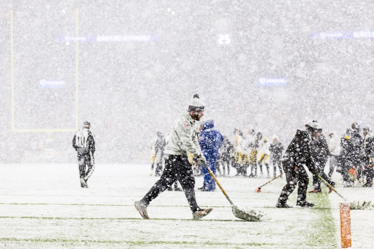 Grounds crew members shovels snow off the yard lines on a football field
Earlier in November, the Transportation Security Administration had projected that Sunday would be one of the year’s three busiest travel days, exacerbating the impact of the arctic blast. Lake effect snow occurs when a cold air mass moves southward from Canada over the warmer Great Lakes, drawing moisture into the atmosphere, forming clouds, and producing snowfall rates of 2 to 3 inches per hour or more. Water temperatures for Lake Erie and Lake Ontario on Sunday morning were each 46 degrees at a depth of 30 feet or more, indicating even warmer surface temperatures. While the arctic blast’s intensity was expected to diminish early in the week, forecasters cautioned that more cold air was heading southward from Canada, suggesting continued below-average temperatures across much of the eastern United States.