
Planning a trip to Washington D.C.? One of the first things you’ll need is a reliable Dc Travel Map to help you navigate the city and discover all the incredible sights it has to offer. The good news is that Washington D.C. is a very walkable city, especially the main tourist areas. With the right map, you can easily explore iconic monuments, world-class museums, and historic neighborhoods on foot.
To make your trip planning easier, we’ve compiled a collection of the best Washington DC maps. Whether you prefer a traditional print map or a digital version for your smartphone, you’ll find the perfect DC travel map here to guide your exploration. Below are ten essential maps of Washington D.C. that you can use to plan your itinerary and navigate the city like a pro.
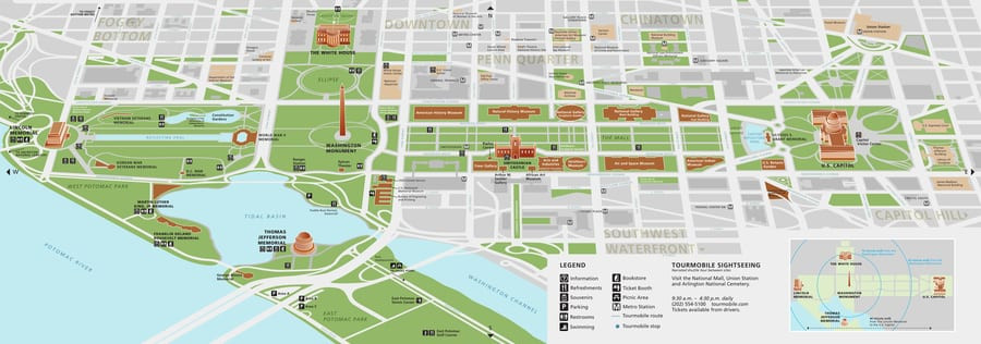
Washington, DC Tourist Map
To begin, let’s get an overview of the city with a comprehensive tourist map of Washington, DC. This type of map is perfect for getting a feel for the layout of the city and identifying the major attractions you won’t want to miss. It’s a great starting point for planning what to do in Washington D.C. and visualizing the distances between key landmarks.
[Washington, DC tourist map]
Interactive Washington, DC Map
For a more detailed and dynamic planning experience, an interactive map of Washington, DC is invaluable. These maps allow you to zoom in on specific areas, click on points of interest for more information, and even get directions. This interactive DC travel map highlights key memorials, museums, the White House, and many other attractions, helping you explore the city in depth.
If you notice any must-see spots missing from our interactive map, please let us know in the comments, and we’ll be sure to add them! And the best part? We’ll also show you how to access this map offline, so you can have it with you at all times, even without an internet connection.
Washington, DC National Mall Map
Many of Washington D.C.’s most famous sights are located within the National Mall. A dedicated map of the National Mall in Washington, DC is essential for navigating this iconic area. This map focuses on the stretch from the Lincoln Memorial to the Capitol Building, including monuments, memorials, and Smithsonian museums. It also often includes a Smithsonian museum map, as many of these renowned institutions are located along the Mall.
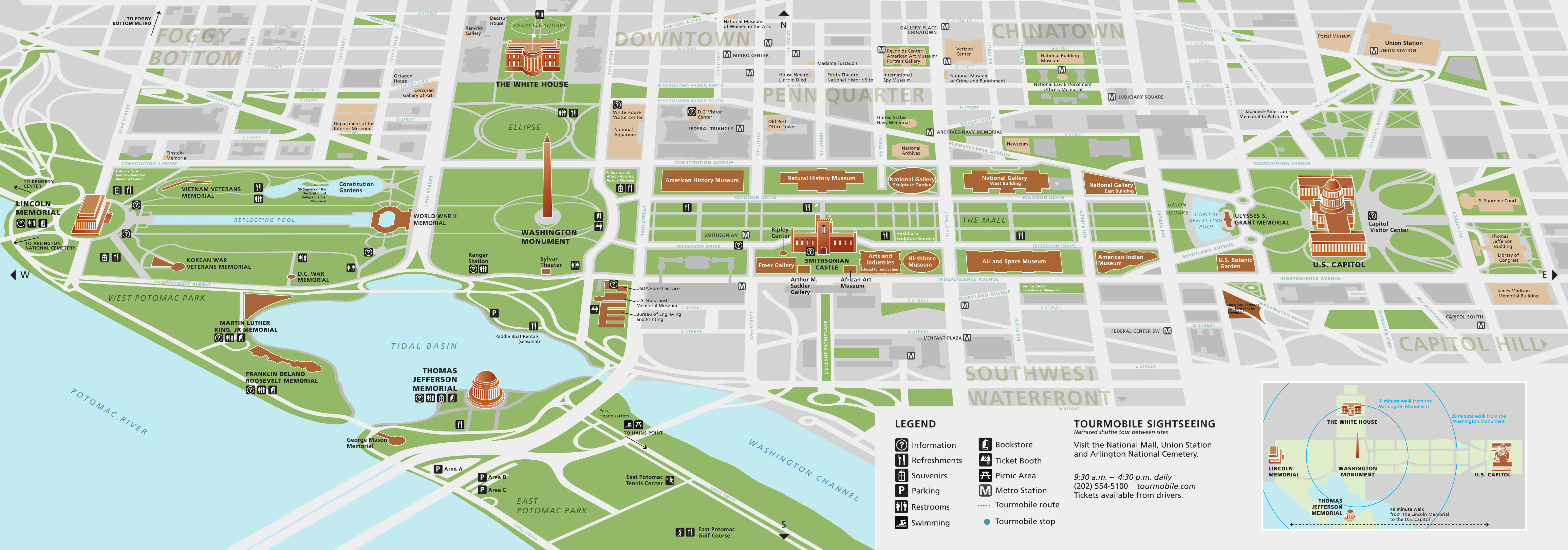 The map of the National Mall of Washington D.C.
Washington, DC Street Map
For detailed navigation on foot or by car, a Washington, DC street map is indispensable. This type of map shows you the intricate network of streets, roads, and avenues throughout the city. With a street map, you can confidently explore different neighborhoods and find your way from point A to point B with ease. You’ll never have to worry about getting lost in this amazing city!
[Washington, DC street map]
Washington DC Neighborhood Map
To truly understand the character of Washington D.C., it’s helpful to explore its diverse neighborhoods. A Washington, DC neighborhood map is perfect for this. It outlines the boundaries of different areas like Georgetown, Capitol Hill, Dupont Circle, and more, each with its own unique atmosphere and attractions. Use this map to decide where to stay in Washington D.C. or to plan explorations beyond the main tourist areas.
Washington DC Public Transport Map
While walking is a fantastic way to see D.C., sometimes you need to cover longer distances quickly. That’s where public transportation comes in. A metro map of Washington, DC, also known as a Washington DC public transport map, is essential for utilizing the city’s efficient Metro system. This map shows you the different Metro lines, stations, and connections, making it easy to navigate the city via rail.
[Washington, DC Public Transport Map]
Washington, DC Road Map
If you’re planning to drive in or around Washington D.C., or perhaps take day trips to nearby areas, a Washington, DC road map is a must-have. While navigating the city center by car isn’t always recommended due to traffic and parking, a road map is still useful for reaching destinations outside of downtown or for planning your route into the city.
High-Resolution Washington, DC Map
For the ultimate level of detail, a high-resolution Washington, DC map is perfect. These maps allow you to zoom in incredibly close, revealing even the smallest streets, landmarks, and points of interest. With a high-resolution DC travel map, you can ensure you don’t miss a single thing in the capital.
[High-resolution Washington, DC map]
Map of the United States
To put Washington, D.C. in geographical context, a map of the United States showing the location of the capital is helpful. This map illustrates where Washington, D.C. sits within the country, useful for those traveling from other parts of the US or for international visitors wanting to understand the city’s national significance.
Washington, DC Map for Downloading
Finally, for ultimate convenience, a Washington, DC map for downloading is ideal. Having an offline map on your smartphone means you can access it anytime, anywhere, even without a data connection. For example, using apps like Maps.me and Dropbox, you can download a DC travel map and access it offline. Simply search for Washington, DC in Maps.me, download the KML file and save it to Dropbox, then open the file with Maps.me to have all the tourist attractions available offline.
[Washington, DC map for downloading]
With this collection of Washington, DC maps, you are now well-equipped to plan and enjoy your trip to the fullest. From tourist hotspots to hidden neighborhood gems, your DC travel map will be your essential companion for exploring everything this incredible city has to offer. Happy travels!