
Millions of Americans are embarking on holiday journeys this Christmas, but winter weather across the U.S. threatens to throw a wrench into their festive plans. While major blizzards aren’t predicted, a series of weather systems promising snow, rain, and icy conditions are expected to impact travel routes nationwide, particularly along the busy Interstate 95 corridor and throughout the Northeast and Midwest. This comes as a record-breaking 120 million people are anticipated to travel during this holiday season, according to AAA, making potential disruptions even more impactful.
 A wintry scene showing snow-covered roads and trees, illustrating the potential travel hazards due to winter precipitation during the Christmas holiday season across the United States.
I-95 Corridor and Northeast Bracing for Pre-Christmas Snow
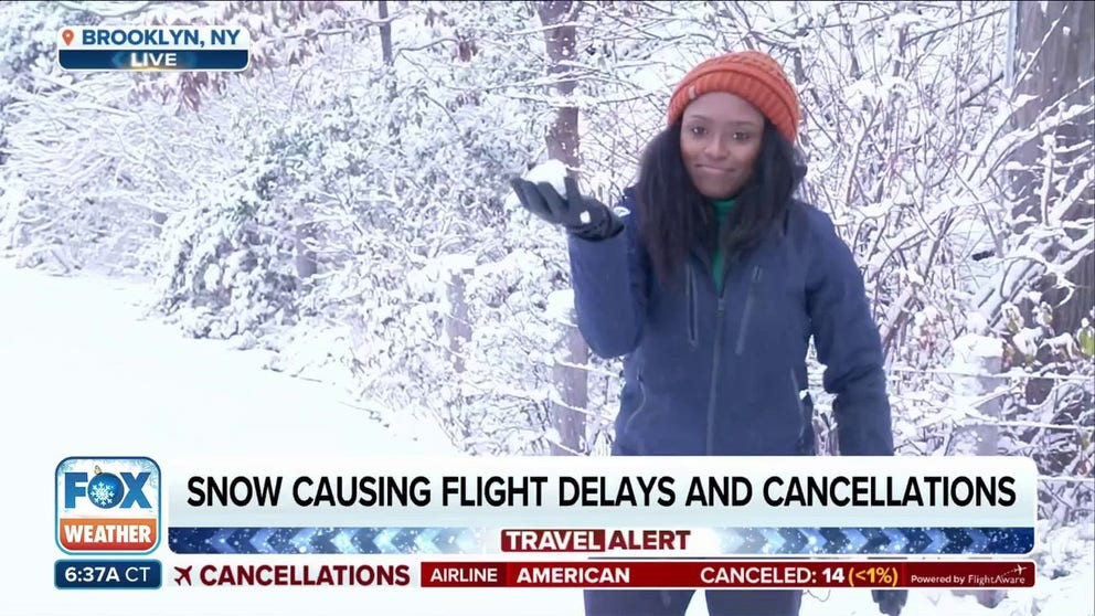
Travelers along the heavily trafficked I-95 corridor from Washington D.C. through Philadelphia, New York City, and up to Boston should be prepared for potential disruptions. Wintry precipitation is forecast to create slick and hazardous travel conditions right on Christmas Eve. This region already experienced a taste of winter over the weekend, with New York City receiving its first measurable snowfall since February.
 A video thumbnail showing Brandy Campbell reporting on the first measurable snowfall in New York City, highlighting the early winter weather impact in the Northeast region.
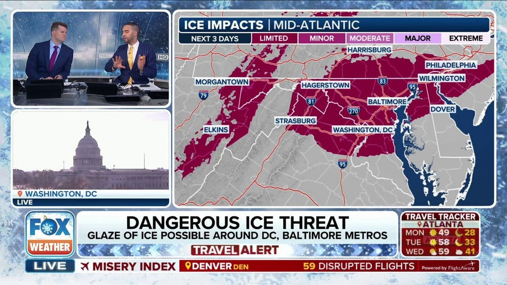
Several inches of snow blanketed parts of the Northeast over the weekend, impacting cities from Philadelphia to Boston. Boston Logan Airport recorded over 5 inches of snow, marking the largest accumulation since the Blizzard of January 2022. Another snow-producing system is now targeting similar areas, threatening to deliver more snow and icy conditions right before Christmas. Winter Weather Advisories are in effect from Wisconsin to Maine, including portions of the mid-Atlantic, signaling potential for freezing rain, sleet, and light snow that could make roads treacherous on Tuesday morning for cities like Washington, Baltimore, and Philadelphia.
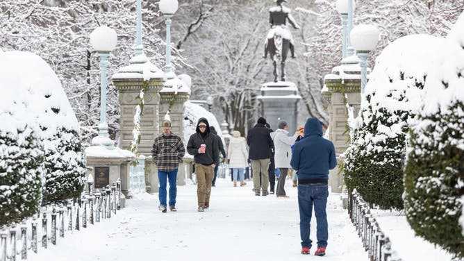 A general view showing people walking through a snow-covered Boston Public Garden, depicting typical winter conditions in the Northeast during the holiday season.
Midwest Faces Snow as Weather System Moves East
A low-pressure system moving across the Great Lakes is responsible for spreading light to moderate snow across Wisconsin and Michigan. This snow is expected to extend into the interior Northeast and New England overnight and continue into Tuesday morning, further complicating travel across the Midwest as holiday travelers move through the region. Anyone traveling on Christmas Eve afternoon should see conditions improve as the snow and wintry mix taper off from west to east.
West Coast Hit by Relentless Rain and Mountain Snow
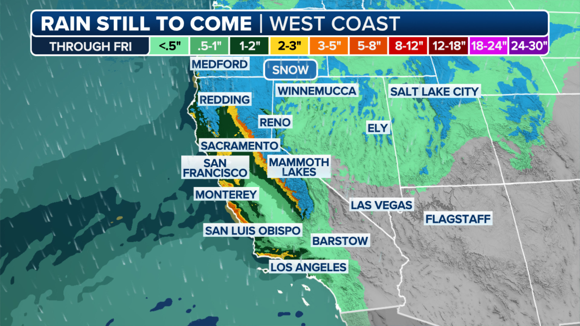
The West Coast is facing a series of storms bringing prolonged periods of windy and unsettled weather. From San Francisco to Seattle, moderate to heavy rain is expected, raising concerns about a low-end risk of flash flooding. Northern California and coastal Oregon could see up to 6 inches of rain through Tuesday. Air travel could also be affected, with potential delays at major hubs like Seattle-Tacoma International Airport and San Francisco Bay Area airports.
 A map showing rainfall accumulation forecast across the Western United States, indicating potential for heavy rain and flooding in the region during the holiday travel period.
While snow levels are relatively high, significant snowfall is anticipated in the Cascade Mountains, northern Sierra Nevada Mountains, and northern Rockies, with feet of snow expected. Another round of rain and mountain snow is forecast for Christmas Day, likely causing further travel disruptions for those heading to or from holiday gatherings in the western states.
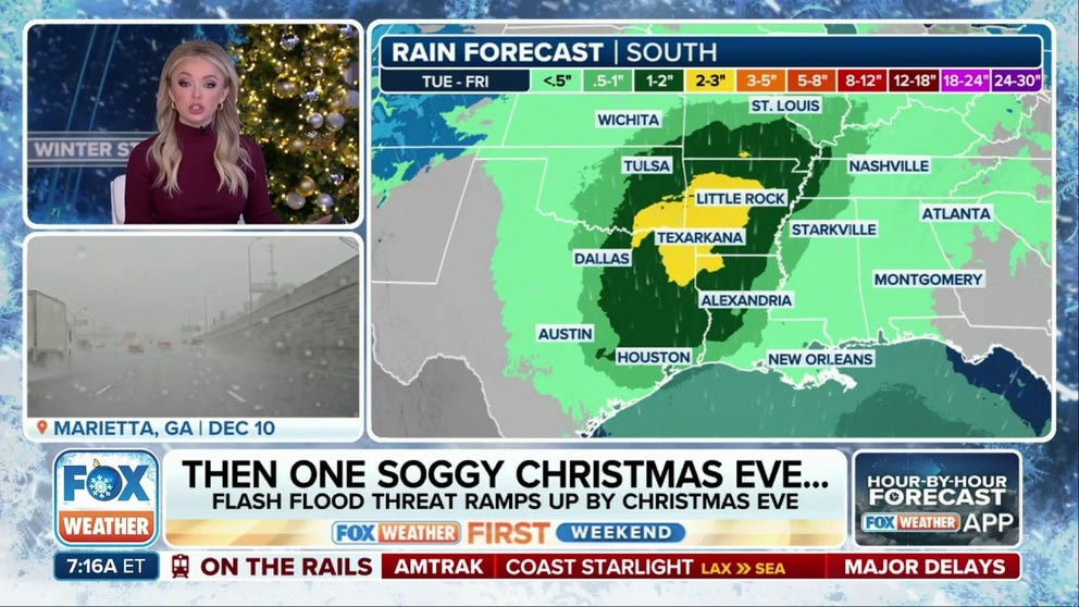
Thunderstorms and Rain Threaten Holiday Travel in the South
The southern U.S. is not escaping weather-related travel headaches either. A developing storm system drawing moisture from the Gulf of Mexico is expected to produce scattered showers and thunderstorms from Texas into southern Missouri. The rain threat will persist through at least Christmas Eve, with some areas in the Ark-La-Tex region potentially receiving 2-3 inches of precipitation.
 A video thumbnail featuring Kendall Smith discussing the flood threat across the Southern United States during Christmas week, emphasizing the impact of heavy rainfall on holiday travel.
Some thunderstorms could become strong to severe, bringing gusty winds, lightning, and heavy rainfall. While the rain is generally welcome in this drought-stricken region, rainfall rates exceeding an inch per hour could lead to isolated flash flooding, further complicating holiday travel plans in the South.
End-of-Year Warmup on the Horizon
Looking beyond the immediate Christmas travel period, a significant weather shift is on the horizon. Forecast models indicate a potential end-of-year warmup for much of the U.S. A strong Pacific jet stream is expected to develop around Christmas, bringing warmer-than-average air across the Lower 48 states and potentially leading to a more active storm track as 2024 concludes and 2025 begins.
 A map displaying temperature departures across the United States, showing warmer-than-average conditions expected in many regions in the coming days.
NOAA’s Climate Prediction Center forecasts highlight this trend, predicting above-average temperatures for nearly the entire Lower 48 states in the week after Christmas. High temperatures are expected to soar 10-20 degrees above average, with over 200 million Americans potentially experiencing this unseasonably warm weather as the year transitions into early 2025. While this warming trend offers relief from the immediate winter weather threats, travelers should remain vigilant and stay updated on the evolving weather conditions as they navigate record-breaking holiday travel across the country.